-
Schedule Appointment Book now
-
Call or text (406) 404-7177
Address Database 2025
Self-hosted street address database
A SQLite3 database file with nearly 160 million U.S. and Canada address records. Indexed for fast queries, even on fairly slow hardware.
Schema
The database contains a single table, addresses, with the following columns:
- zipcode - ZIP Code/Postal code
- number - House number
- street - Street address
- street2 - Apartment/unit/etc number
- city - City name
- state - Two-letter state abbreviation
- plus4 - ZIP+4 code (see notes below)
- country - Two-letter country code
- latitude
- longitude
- source - Data source identifier (see below)
There is also a “lite” version that omits the latitude, longitude, and source columns, as well as several indexes. It is optimized for autocompleting addresses in forms, when the user starts with the house number and street name, and optionally with a ZIP Code (or list of ZIPs) as a filter.
Example of an ideal, performant query on the “lite” database: SELECT * FROM addresses WHERE number="100" AND street LIKE "W MAIN%" LIMIT 10;
The “lite-onlyplus4” variant is the same as the “lite” version but USA records without a ZIP+4 are omitted (over 145 million addresses remain).
Download
Full database file is approx. 35 GB uncompressed (11GB compressed download). Click here for a small sample to test with if you’re not sure about grabbing all that data.
“Lite” database is approx. 23 GB uncompressed (6.7GB compressed download).
Processing and hosting all that data costs money and time. For better data quality, we bought a subscription to the USPS ZIP+4 database, which is not cheap. Pay what you think is fair, even if that’s $0. It’s up to you.
SHA256 Checksums:
3deb85a37c6a4d027dd35fcbc1084e577b06a95be471042acc17fe21dedc3d8e AddressDatabase2025.zip
9d917637013f176d723b701317fb5d51696dd51e159b3fed0a27e4fa55d0d074 AddressDatabase2025-lite.zip
0ce1915480ae55a2b3a88c5c6b87873adc25d983b498fefbc5bcef5feaa86c59 AddressDatabase2025-lite-onlyplus4.zip
Coverage Map
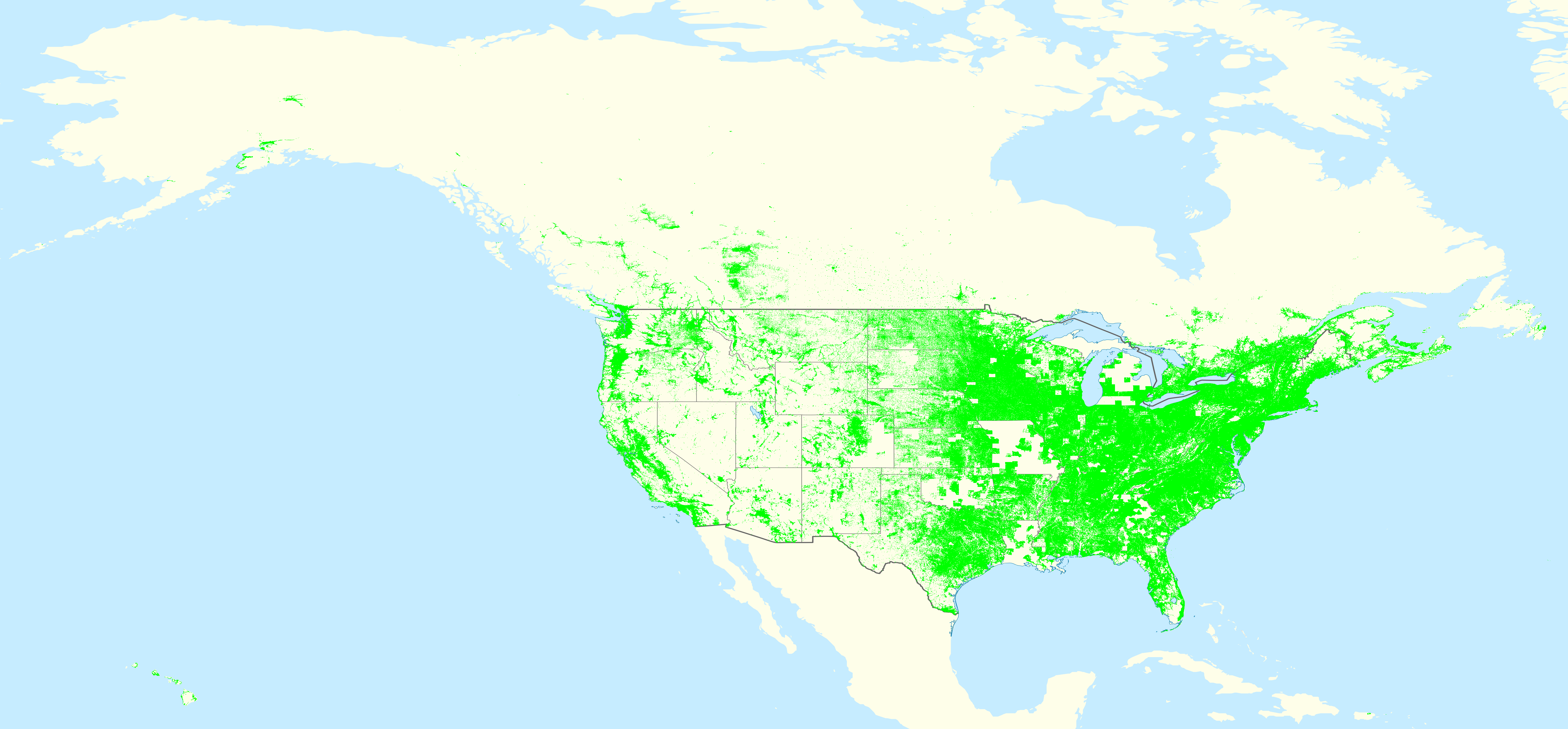
Click image to open in a new tab.
Map generated from only addresses with a verified ZIP+4. Map of all addresses is available here.
Compare to last year.
You can fill in missing areas in the next release by contributing to the OpenAddresses project!
Address Format
United States
Street names were standardized per USPS Publication 28: Postal Addressing Standards.
This year, we included unit designators (APT, STE, etc) when we could get an exact ZIP+4 match for the unit.
The rest of the time, for US addresses, the street2 column will start with a #.
It is recommended to display addresses to the user as [number] [street] [street2]\n[city] [state] [zipcode], where \n is a line break.
Puerto Rico streets should be prefixed with CALLE, but this has been omitted from the database for efficiency and easier matching.
For example, display Puerto Rico addresses as [number] CALLE [street] [street2]\n[city] PR [zipcode].
Street addresses missing ZIP Codes were matched to ZIP Codes using USPS databases with a fallback to ZIP boundary polygon matching.
ZIP+4 (plus4) Notes
New in this release, all addresses were validated against the USPS ZIP+4 database.
Addresses which were successfully matched to USPS data have a 4-digit value in the plus4 column.
Note that the presence of a ZIP+4 does not always mean an address is valid or deliverable;
it simply means the house number is within a range of numbers on that street, and some of the
numbers in that range are valid. For clarity, the USPS ZIP+4 database is basically lines of this:
100 to 199 ELM ST, CITY ST 12345-1234 (except much harder to read). This means we can’t tell if
123 ELM ST exists, only that there is a 100 block of Elm St with the +4 of 1234.
If the plus4 column contains a value ending in ND (for example, 02ND), the address range is
known to USPS but USPS does not deliver there for some reason. There are approximately 653,361 such
address ranges in the USPS data.
There are some addresses where we’ve assigned a valid ZIP+4, but USPS prefers a different +4. This sometimes happens for apartment buildings and similar when our source data doesn’t have unit numbers. USPS typically assigns one or more entire +4 codes to apartment buildings. USPS might decide that an address missing a unit number is deliverable (such as to the main office/front desk), or that mail isn’t deliverable without the apartment number. This can affect the “official” +4 code returned by USPS for an address missing a unit number. We don’t currently have access to the data USPS uses to make this decision.
Canada
Canadian street addresses were published by Statistics Canada already in the preferred Canada Post format, and were used as-is without further processing. Canada Post provided verified addresses to Statistics Canada so they should all be accurate.
Some Canadian PO Boxes are in this dataset. The number field is the PO Box number, and the street is “PO BOX”. If a street equals “PO BOX”, it should be displayed as “[street] [number]\n[city] [state] [zipcode]”.
Sources
United States data:
- National Address Database version 20 from October 2025.
- OpenAddresses project, which collects various government address datasets into a standard data format. We regularly donate to OpenAddresses to cover the costs of downloading their data, and you should too. Data retrieved October and November 2025, with some data re-downloaded after we discovered problems and contributed fixes.
Canada data:
- Source: Statistics Canada, National Address Register, July 2025. Reproduced and distributed on an “as is” basis with the permission of Statistics Canada.
source column
The source column contains either “NAD [org name]” for data from the National Address Database to
indicate the government agency which provided the data, or “OA/[source]” for data via
OpenAddresses. For statewide datasets from OpenAddresses, the source will be similar to “OA/AK”
(two-letter state abbreviation), while for county-level and city-level data it will be “OA/[county or city name]”.
Canadian addresses have a source field of “StatsCan NAR”.
Copyright
Under United States copyright law, facts and collections thereof, such as a phone book listing, are not creative works, cannot therefore be copyrighted, and as a result are in the public domain.
Due to the effort involved sourcing this data, writing software to sanitize it, manually spot-checking for accuracy, contributing changes upstream to OpenAddresses, and finally compiling it into a clean, indexed database, we kindly ask you to send other people here instead of giving them the file yourself.
Some of the addresses are from proprietary sources, because some counties make deals with private companies to manage their GIS data. These companies typically sell access to the dataset including property owner names for real estate marketing and similar purposes. We did not pay for this data, and OpenAddresses typically scraped it from their free web map viewer instead. There isn’t really anything those companies can legally do about this because facts can’t be copyrighted, and we think this data shouldn’t be paywalled because of its value to humanity so we’d happily pirate it regardless.